FOB Price
Get Latest Price|
1 Box Minimum Order
Country:
China
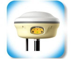
Model No:
R1
FOB Price:
Place of Origin:
-
Price for Minimum Order:
-
Minimum Order Quantity:
1 Box
Packaging Detail:
in new strong boxes
Delivery Time:
7 Days after receive the T/T payment.
Supplying Ability:
1000 Box per Month
Payment Type:
T/T
Product Group :
Contact Person Amy
Wuhan, Hubei
◆
Initiating RTK + Pad fieldwork
mapping system in China
◆
Dual
power supply design, industry's highest large capacity Li-ion
battery, supports hot plug power battery replacement
◆
Configured with software
supporting GPS, GLONASS, and Compass carrier phase
◆
Seamless
compatible with various CORS systems
◆
Linux
intelligent system
◆
Support
GPS, GLONASS, Compass, Galileo
◆
Support
WASS, EGNOS, MSAS, GAGAN
◆
Fast
initialization and satellite tracking technology
◆
Intelligent fault diagnosis and
audio reminder function
◆
Built-in
high-performance processor can process *0Hz data
◆
Built-in
transmitting-receiving UHF radio, 3G/GPRS, Bluetooth
◆
Support
one-key setup for base
◆
Standardized design, exchangeable
base and rover
eFix
R1 series application
◆
High
accuracy RTK survey
◆
High
accuracy wide range control survey
◆
Construction stakeout
◆
Various
industry data acquisition
◆
High
accuracy marine survey
◆
For
electric power, transportation, agriculture,forestry and land
applicatio
GeoRef
K2E
R1
controller, also working as a high sensitive industry-level
handheld receiver
GeoRef K2E is with Windows CE 6.0/Windows Mobile 6.5 operation system and built-in 1GHz industry-level processor, while supporting *0GB or even larger raster image loading and **0 MB level vector data loading, providing comprehensive GPS/GIS software application solutions.
GeoPac
- Professional Collecting
Software
GeoPac is
the latest multifunctional GNSS data collection, processing and
management software, containing data collection, edition,
detection, analysis and storage, which is widely applied in
different fields such as engineering survey, road engineering,
water conservancy, forestry and etc.
◆
Comprehensive functionalities,
meeting both requirements
of high-accuracy engineering survey and
field data collection.
◆
High-accuracy rapid positioning
can meet different
accuracy requirements.
◆
User-friendly interface makes
heavy-duty fieldwork easy
and convenient.
◆
Universal
coordinate systems with the popular Gauss,
UTM, Mercator projection, etc.
◆
Various
convenient coordinate transformation tools,
making plane *-parameter, spatial
*-parameter and
*-parameter transformation
easier.
◆
Powerful
process and performance as well as very
fast
and smooth operations based on advanced
calculation
technology, even with over ***0 points
collected.
◆
Multiple
professional data collection methods.
◆
Complete
attributes library and easy setup make data
collection, edition and management
super-easy, greatly
increasing fieldwork
efficiency.
Engineering Survey
The
built-in extension module specially designed for engineering
survey:
◆
Provide
professional high-accuracy solution for RTK
survey with self-built base or the one
based on CORS.
◆
Convenient management for stakeout
point library, control
point library and detail point
library.
◆
Avoid the
conventional defect of error accumulation in
handset built-in software, significantly
improve the
survey accuracy.
◆
Powerful
post-processing software enables survey more
flexible with more accurate
results.
Road
Engineering
The
built-in extension module specially designed for road survey
application:
◆
Powerful
and practical design features.
◆
Flexible
stakeout mode with navigation function.
◆
Support
various stakeout of transition curves, easy and
convenient to operate.
◆
Support
center line, profile and template edition and stake
out for road application.
| Country: | China |
| Model No: | R1 |
| FOB Price: | Get Latest Price |
| Place of Origin: | - |
| Price for Minimum Order: | - |
| Minimum Order Quantity: | 1 Box |
| Packaging Detail: | in new strong boxes |
| Delivery Time: | 7 Days after receive the T/T payment. |
| Supplying Ability: | 1000 Box per Month |
| Payment Type: | T/T |
| Product Group : | GNSS INSTRUMENT |


 --Meter Accuracy")


")


