FOB Price
Get Latest Price|
1 Piece Minimum Order
Country:
China
Model No:
IGS110
FOB Price:
Place of Origin:
China
Price for Minimum Order:
-
Minimum Order Quantity:
1 Piece
Packaging Detail:
Firm
Delivery Time:
One day
Supplying Ability:
-
Payment Type:
T/T, L/C, D/A, D/P, Western Union, Money Gram, PayPal, Other
Product Group :
-
Contact Person Mr. Yueqi
Jiachuang Road 5, Beijing, Beijing
Our company is a
professional GPS manufacturers and service providers in China
worthy of your trust.Long been engaged in GPS production,
development, sales and maintenance.Please contact us products and
services.
Contact: Manager Liu.
Tel: **6 **********8.
QQ:********9
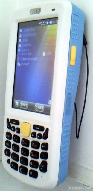
IGS**0 handheld
gps / GIS data collector
Key Features:
Real- time meter accuracy
Integrated communications
Long life battry for professional
cost-effective mobile GIS mapping solutions
IGS***0 is based on Windows mobile 6.5 operating system, and it has high-resolution 3.*-inch **0X**0 pixel touch screen, with wireless LAN and WAN 2.*5G Netcom Communications and data transfer, support for GPS, **0 million auto-focus camera and video, support one, two dimensional scanning laser or image reading, support *3.*6Mhz RFID reader, Bluetooth 2.0 short distance data transmission.
IGS***0 is an ideal, cost-effective mobile GIS mapping solutions, in addition to the application of highly integrated functions, it is in strict accordance with industry standard IP*4 package designed to meet the concrete floor 1.2 m drop test. And is equipped with a safety ***0mAh lithium polymer battery, to meet the equipment at full capacity *2 hours work!
TECHNICAL
SPECIFICATIONS:
GNSS Characteristics
Internal antenna: *2 channels
- GPS L1 C/A
- SBAS:WAAS/EGNOS/MSAS
External antenna connector
NMEA****3 and Sirf Protocol output 1Hz
TTFF:*0s
Accuracy Specifications (Horizontal RMS)
Real-time SBAS: **5m typical
Processor
ARM architecture Hisilicon **0MHZ
Operating System
Microsoft Windows Mobile 6.5 Professional
Software package includes:
- Internet Explorer?
- Office Mobile
- ActiveSync?
- Transcriber (handwriting recognition)
Communications
Cellular
Built in GSM/GPRS
**0/***0 MHz
Bluetooth
Bluetooth 2.0 with EDR
WiFi
Integrated **2.*1b / g
Interface
USB
Mini USB interface / charge cradle
GPS
with AGPS function Srif Star III navigation chip
Physical Characteristics
Size
**5x*0x*6 mm
Weight
**5g
User Interface
Keyboard
side
power
the front of *0 keys keyboard
Display
3.5 inch, HVGA (**0X**0) TFT high-brightness, touch screen
Touch Panel: Glass analog resistive touch screen
Backlight:: LED backlight
Memory
**6MB Flash ROM + **8MB SDRAM
Mini SD cards up to *2G
Environmental Characteristics
Operating temperature:
**0°to + *0°C
Storage temperature:
**0°to + *0°C
Humidity: *5% non condensing
Waterproof: IP*4
Free drop: 1.2 m on concrete
Power Characteristics
3.7V ***0mAH Li-polymer
Battery life: > *2 hrs
Charge time: 4 hours
Removable battery
Electrostatic Discharge:
+ /**5kV air discharge, + /*8kV direct discharge
Multimedia & Sensors Camera 3M Pixels
Speaker
Microphone
Data collection specifications (Option)
Bar code: one-dimensional laser imaging,
two-dimensional image scanner
RFID *3.*6MHz, compatible with ****3/****3 protocol
One-dimensional laser scanner(Option)
Optical resolution: greater than or equal 4mil
Scan Depth: 3.*1 cm **0.*8 cm
Scan angle: *7°± 3° (standard)
Scan speed: **2±*2 times per second (bi)
Two graphics scanner (Option)
Optical resolution: greater than or equal 3mil
Scan angle: all the
Scan speed: **0 times
Standard Accessories
Stylus
Hand-strap
A/C charger
USB cable
IGS***0 is based on Microsoft Windows Mobile 6.5 operating
system, provides an open platform to support third-party software,
As a leader in the field of GIS, it can enable users to install
third-party GIS software. Such as ESRI's ArcPad software.
| Country: | China |
| Model No: | IGS110 |
| FOB Price: | Get Latest Price |
| Place of Origin: | China |
| Price for Minimum Order: | - |
| Minimum Order Quantity: | 1 Piece |
| Packaging Detail: | Firm |
| Delivery Time: | One day |
| Supplying Ability: | - |
| Payment Type: | T/T, L/C, D/A, D/P, Western Union, Money Gram, PayPal, Other |
| Product Group : | - |


")


